

A MAGAZINE DEDICATED TO OZARKS
Tornadoes, severe storms, straight line winds, oh my!

Dramatic aerial photos taken by Linus Cambells
The central area of the United States sees approximately 1,000 tornadoes each year.
The deadliest tornado in U.S. history happened on March 18, 1925, hitting the area of Missouri, Illinois, and Indiana, which gave it its name, The Tri-State Tornado.
According to the Storm Prediction Center, the five deadliest tornadoes in U.S. history are as follows:
#1 — March 18, 1925, The Tri-State Tornado, 695 deaths
#2 — May 6, 1840, Natchez, Mississippi, 317 deaths
#3 — May 27, 1896, St. Louis, Missouri, 255 deaths
#4 — April 5, 1936, Tupelo, Mississippi, 216 deaths
#5 — April 6, 1936, Gainesville, Georgia, 203 deaths
The list itself mentions another 20 tornadoes between 1860 and 2011 that took more than 3,000 lives combined. Some of which hit extremely close to home.
On May 22, 2011, the Joplin tornado killed 158 people — the most deadly the U.S. had seen for more than half a decade. On April 18, 1880, a tornado hit Marshfield and killed 99 people. May 9, 1927, sent a tornado to Poplar Bluff, which took the lives of 98 people.
Tornado Alley was coined in 1952 for a research project studying severe storms. Also known as the Tornado Belt, specifically referring to the great plains, the area goes as south as Louisiana and north as the Canadian border, placing Missouri nearly perfectly in the middle.
Jet streams, warm moist air, cold dry air, and warm dry air create the perfect breeding ground for E.F. 3, 4, and 5 tornadoes.

Near Victoria, Kansas. on May 26, 2021.
Photo by Cade Woolaway
When Severe Weather is on Its Way
Mike Phillips, Barry County E9-1-1 director, and Eddie Laning, Barry County E9-1-1 operations manager, said severe weather training for dispatchers begins in March.
“We provide awareness training and keep an eye on the radar and the local skies,” Mike said. “We receive an email from the National Weather Service (NWS) when we expect significant weather.”
This keeps the dispatchers and the firefighters aware of what is possible over the next few hours.
“NWS gives us indicators, so we don’t have to interpret weather data,” Mike said. “When it is time to sound the sirens, our local Emergency Management will give us the call.”
Eddie said radar can anticipate what is coming during severe weather.
“If Emergency Management says storm spotters are needed — we send out the page,” he said. “For whichever area, web page out the fire departments.”
Mike said it is up to the individual Fire Chief to go out or not. Usually, that is dependent on training.
“The Fire Department gives us field reports,” Mike said. “For example, they may tell us, “I have pea-size hail,” or “There are high winds at Hilltop.”
Internally, the 911 dispatchers then create a CAD incident to track all their data.
“That data goes to Emergency Management, who then hands it over to NWS,” Mike said.

Severe Storm over Wheaton, Missouri, on August 12, 2021.
Photo by Cade Woolaway
Siren Activation
Tornado warnings are issued through the NWS. From that, by local Emergency Management request — storm sirens are sounded.
“There are three ways a siren can be activated,” Mike said. “If we are indicated by the NWS to activate, through a phone call from a trained fire or police chief, or by Emergency Management.”
Eddie said for the general public, while they understand the natural response to notify 911 unless they have storm spotter training, they should trust that trained individuals are on the job.
“When it comes to storm siren warnings,” he said, “People should remember they are outdoor warnings. You are not meant to hear them indoors — if you can, you are lucky, but do not rely on a tornado siren when you are indoors.
“The siren sounds for three minutes, then rests for three minutes. That cycle continues until the NWS notifies us to turn it off.”
People should have access to cell phones, radios, TV, or other ways to receive warnings and notifications while they are indoors.
“In severe weather situations, if sirens are going off — there is a reason,” Eddie said. “911 dispatchers are in constant contact with multiple fire and police departments during a severe weather event. Trust the trained individuals.”
The general statement is that people should be prepared for three days in a severe weather event.
“Dispatchers are sent off for training to deal with weather events,” Mike said. “There are supervisors on-site to manage, and we test the sirens monthly.
“The 911 center is the sole location to have sirens activated. It is built to withstand an EF5 tornado, we have a generator to power all of our equipment, and we have a high wind resistant towers to keep everyone informed.”

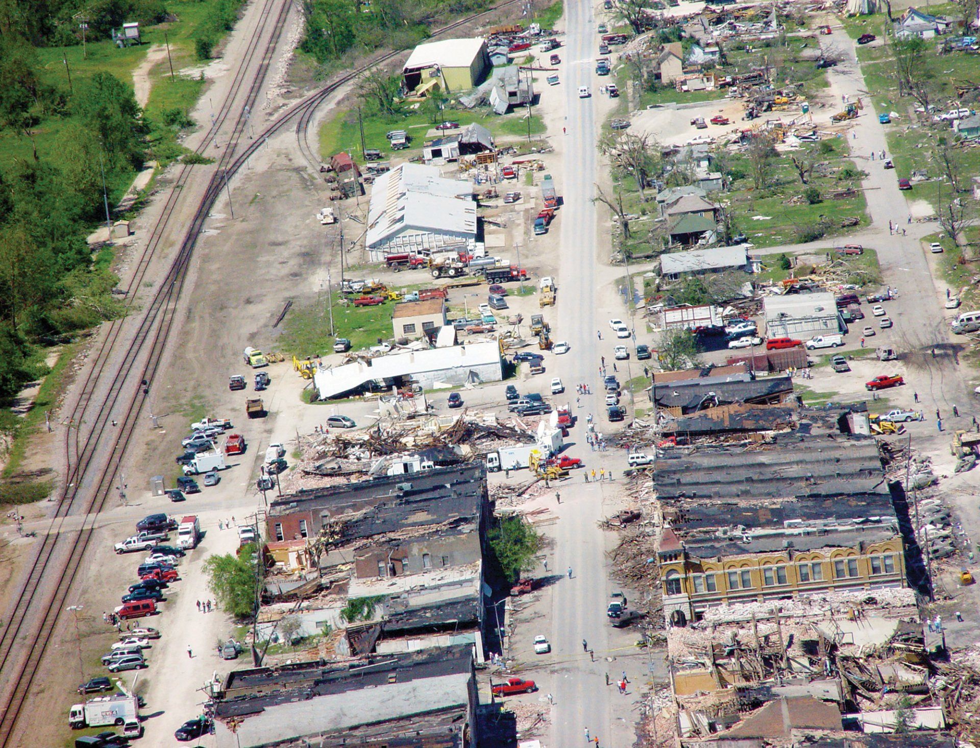
Pierce City Armory following the destruction of the tornado that devastated the small town on May 4, 2003.
Photo by Pete Rauch

Rotating Wall Cloud near Victoria, Kansas, on May 26, 2021.
Photo by Cade Woolaway
On the Ground
Storm spotters are deployed during a severe storm event to help keep the local agencies, and the NWS informed.
Cade Woolaway, a 2021 Wheaton graduate, is 19 years old and attending the University of Oklahoma, studying to become a meteorologist.
“It takes a lot of math and sciences to become a meteorologist,” Cade said. “I am lucky that O.U. is one of the best, if not the best, meteorology schools.
“Their School of Meteorology is one of the biggest in the nation and is housed inside the National Weather Center.”
Cade is in a four-year program.
“My end goal is to be on the research and operations side of storms,” he said. “As an NWS employee, or with Emergency Management.”
Cade served with the Wheaton Fire Protection District from January 2020 to July 2021 before leaving for college.
“We didn’t have anything that directly hit the district area during my time, but we did have some straight-line wind damage on the north side of town,” Cade said. “I enjoy a thunderstorm, but it is solely for research if I go out to one. I am trying to learn as much as I can as a first-year student.”
Cade said people often misinterpret storm spotters as storm chasers.
“That is not the case at all,” he said. “Storm chasers go after the storms, sometimes for footage or research, but storm spotters keep an eye on things to relay that information back to local organizations or the NWS.
“Many times, spotters are out well before a storm hits hard. This allows them to get a good vantage point.”
Spotters get the information to the NWS, and the NWS interprets that information with radar.
“Spotters are mainly looking for signs of rotation or something that seems suspicious,” Cade said. “In general, the main threat is rotation.
“Storms that are “supercells” or large storms with a wall cloud will shift down and look like it is lowering. There isn't much to worry about if there is no rotation in that, but if there is rotation, that is the beginning.”
That could be a warning on-site, as a funnel cloud is usually reported before a tornado touches down.
“I developed an interest in storms early,” Cade said. “It was around kindergarten I knew I wanted to know everything about storms. By second grade, I knew I wanted to go to O.U. and become a meteorologist.” Cade remembers around that time, the show Storm Chasers was on TV.
“In high school, I had to stay on top academically,” he said. “Academics was always first and foremost. That was my plan to get here, and years later, here I am.” Cade said there have been some occasional areas of storm activities in the “offseason" over the past few years.
“That is why people have to stay prepared for severe weather 24/7, 365,” he said. “This time of year, things are starting to ramp up. But, no matter what the season is in Missouri — be prepared.”
Cade said it is looking to be an average season this year.
“The winter was normal, and typically, when that happens, the storm season is average as well,” he said. “While some weather patterns form, each weather event is its own.”
Cade in available through Facebook for people to access, https://www.facebook.com/WoolawayWx.
“I developed a website in 2018,” he said. “The current one is much more advanced, and I have been rebuilding it since 2021.
“It allows me to post things which can be shared outside of Facebook. It has a forecast that people can easily access and allows text alerts and discussions.”
Advice for the public when dealing with severe storms:
“Have several ways to get warnings,” Cade said. “Sirens are meant for outdoor warnings. People should have two to three ways to receive alerts.”
What is a warning versus a watch?
“A watch happens beforehand,” he said. “It allows resources to get manned, storm shelters to open, and people to get prepared. It is determined that conditions are favorable for a tornado.
“A warning means all of the ingredients have come together — take shelter now.”
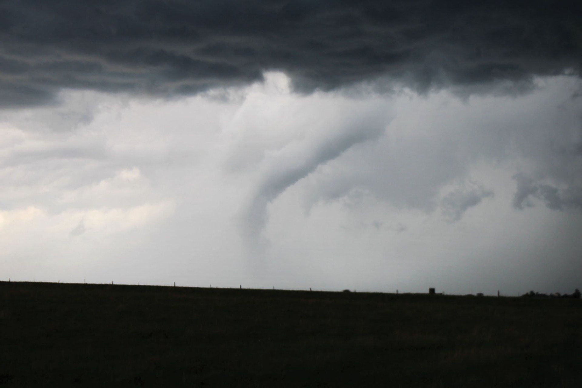
Funnel/ Near Victoria, Kansas, on May 26, 2021.
Photo by Cade Woolaway
When disaster strikes
On the warm Sunday evening of May 4, 2003, just after 7 p.m., the sky over Pierce City turned green, but not the welcoming Kelly Green known throughout the city.
Shortly after storm sirens sounded, the Pierce City tornado ripped through the city, leaving behind mass destruction and the loss of one life, Dale Taunton.
Like many others in the downtown area, Dale Taunton sought refuge at the city Armory, which was built in the 1940s.
The tornado left behind a city ravaged, debris filling the streets, more than 70 homes destroyed and many businesses and buildings in the downtown area demolished — including the Armory.
David Jones, the current Pierce City Fire Chief, said he was a firefighter for Pierce City; he was 29 years old at the time of the 2003 tornado outbreak.
“A call came in for storm spotter activation,” he said. “I went to the station and got a truck. We were well ahead of it at that point.”
In 2003, the city didn’t have the number of storm sirens they have now, so the firetrucks would be put on routes to sound the alarms.
“That's what I was doing when it came in,” David said. “My position was downtown Pierce City.”
The tornado was forming west of town and coming in quickly.
“I remember the sky turned green,” David said. “It was an odd color. I ended up riding it out behind a carwash. I ended up over there because I was heading west for a better vantage point as a storm spotter.”
The firefighter/storm spotter further to the west of Pierce City reported a tornado had touched down.
“I remember thinking I couldn’t see it,” David said. Within seconds the tornado was in town, and shortly after that, it was gone.
“It was chaotic,” he said. “Everyone was trying to give reports to [911] dispatch so, after the fact, we would know where to look.”
At this time, David was helping direct other departments through debris.
“There was so much devastation,” he said. “Departments came from all over to help. I think Monett was here in 10 or 15 minutes. But so many came to help.”
David said the scene was one resembling a war zone.
“All of the buildings were from the 1800s and brick,” he said. “There was brick everywhere.” In the aftermath, the public was left stunned and confused.
“It was mass chaos,” David said. “There was no way to control that, but most people were coming out and trying to help.” David said there were many people inside the Armory, which was the understood designated shelter.
“It was hard to determine where to start and where to finish,” David said. “We got an emergency command center up at some point, and at 1 or 2 a.m., we still didn’t have power.
“Many firefighters worked through the night.” David said the next few days and even weeks ran together after the Pierce City tornado.
“I remember that, for a while, every time a storm got brought up or was on its way, people were really on edge,” he said. “The highways were shut down for days. FEMA came in and helped with the clean-up. It was late July or maybe even August, and they were still tearing buildings down and removing debris.”
David said a lot has changed over the years regarding modernized equipment.
“I think the biggest takeaway is to have a plan,” he said. “Even if that plan gets canceled in a non-event, it is better to have been prepared instead of waiting until the last minute.”